The game plan for today was to take the scenic drive up to the Wheeler Peak area, or get as close as I could. Then I was going to figure out which of the many hikes available depending on where the roads were open.
The scenic drive was just that! Scenic!


Turns out that the only part of the drive I couldn’t do was the campground at the very end! Two of the four campgrounds in the park are currently closed. One is closed due to a road resurfacing project. The other because there is still too much snow on the road leading into it.
So I needed to make a decision or two. Do I go all out and try the “Wheeler Peak trail. (Rated strenuous, 8.6 miles and totally snow packed) or do I use the brain that god gave me and do something else that is survivable.
I chose to do two hikes that are connected to each other. The first one was the Bristlecone Trail (Rated Moderate, 2.8 miles long and according to the Information Rangers…… has some snow on the path). The second trail I chose to do was the Alpine Lakes Loop (Rated Easy, 2.7 miles long and according to the Information Rangers, has some snow on the path)
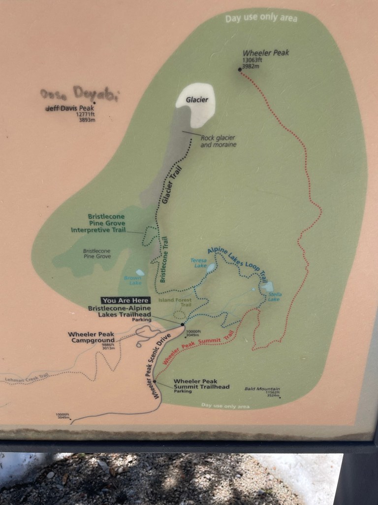
Here is a tip. If you are going on a hike….. bring a trail map. If you are like way too many people….. who get a map and leave it in the car or at home ….. take a picture of the sign with your phone. That way you will always have it with you!
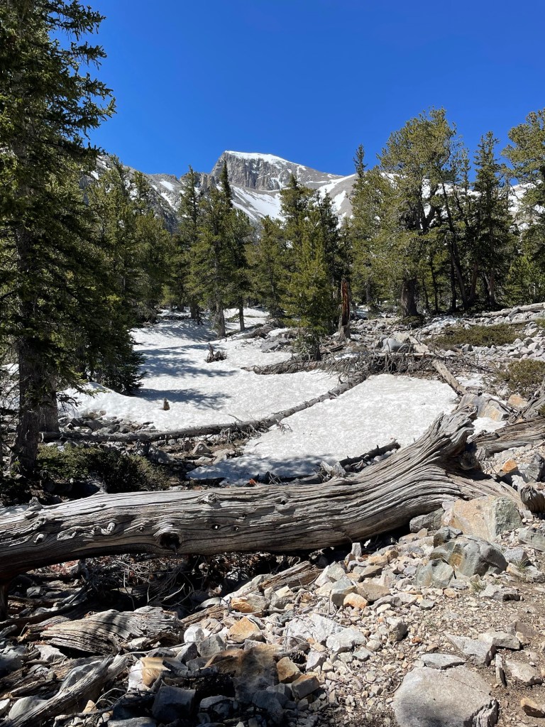
So… back to the hikes I did today. I guess I should have figured that if you are wanting to go hiking at altitudes higher than 10,000 ft in the month of June, you might just run into different forms of water along the way. Primarily the still frozen kind. That’s right, I’m talking about SNOW. Lots and lots of it…. In various states of turning back into good old fashioned water, running down the side of a mountain.
The funny thing about snow after it melts…. It succumbs to the laws of physics! It has to take the pathway of least resistance when it is following the call of gravity.
You know how they decide where to put the hiking paths on the mountain? They put them where there is the least amount of resistance whenever possible. So….. you have these nice paths carved out of the mountain and at this time of year they are either totally snow packed or…. The melting snow is using these paths to get to the bottom of the mountain. In other words …. In another month an easy hike will truly be an easy hike. This time of year…. It’s anybody’s guess what it should be rated!!


Bristlecone Pine trees can live as long as 4000 years! Just image what has happened to their surroundings in that length of time!


A big portion of the Bristlecone Trail was a huge snow field that was at about a 45 degree angle. You had to transverse the field on snow that was anything but stable! So I got my nerves tested today!
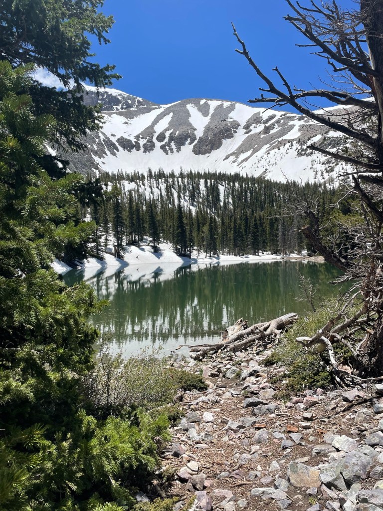
After I finished the Bristlecone Trail, I did the Alpine lakes loop. I passed two Alpine lakes along this trail Teresa Lake and Stella Lake.

By the time I finished, I had walked 14,651 steps or 6.13 miles!
Tomorrow I get to go on a Cave tour! And then some more hiking. I’m going to go in search of some of the wildlife here.

Leave a reply to tp46612011 Cancel reply